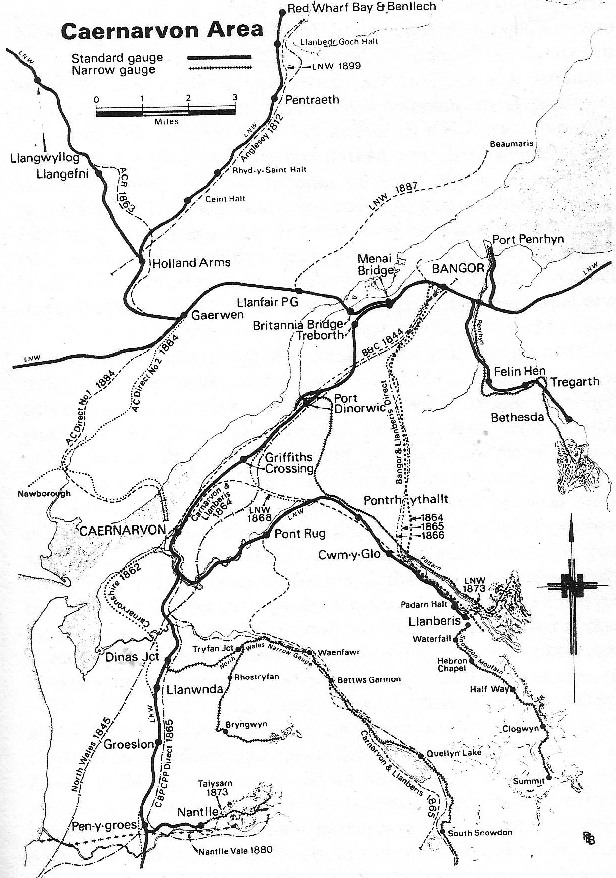
Newborough/Niwbwrch & Tal-y-foel
Anglesey Light Railways
00, London North Western/London Midland & Scottish Railways
| Newborough |
Tal-y-foel,
Cemaes,
and
Beaumaris are aspirations.
Newborough/Niwbwrch
& Tal-y-foel
There are disagreements about dates but 1884-1914 here were plans to build
a railway into South-East Anglesey. Initially a branch line then after the turn of the century
a light railway.
Anglesey & Caernarvon Direct Railway No.
1.
1893 Gaerwan to Tal-y-foel and ferry to Caernarvon.
Anglesey & Caernarvon Direct Railway No.
2.
1894 Gaerwan to Tal-y-foel and ferry to Caernarvon plus
a triangular Junction at Dwyran and a line to Newborough so trains could run via
Newborough.
The line between Gaerwan and Tal-y-foel was on a slightly different
route to No. 1.
South Anglesey Light Railway.
1909 Gaerwan to Newborough and Tal-y-foel. A light
railway variant of No. 2.
Newborough Llangeinwen Llanidan Llanddaniel-fab &
LIannhangei-Esgeinog
Newborough/Niwbwrch
Lies on the same ridge as Hengae Granite Quarries and there is a sand pit to the
west of the village suggesting aggregate traffic.
The sandbanks in the Straits, particularly the quicksand of Traeth Gwyllt,
caused problems.
It's unclear if the
outlier either side of the Menai Straits was worked but if it was coal traffic
is possible.
Location
the main body of is
9Km
long and covers an area of 25km square,
underlying the wetlands of Malltraeth Marsh,
between Llangefni and the Cefni estuary.
There is an out
outlier either side of the Menai Straits.
Sketch map of the Anglesey Coalfield
History
Coal was mined from the mid fifteenth century to the closure of Pont
Marquis colliery in the early 1880s. During the early years of the twentieth
century a committee was formed to reopen the coalfield at Llangristiolus but the
middle class and farming gentry did not support the venture.
Geology
This coalfield is an outlier of Westphalian strata (Langsettian substage).
Coal Measures are known to a depth of 358 m although the base of the succession
has not been proved. Their are at least 8 seams with only three being in excess
of 0.4m thick of which
two exceeded 2m thick.
Mining ceased before there was routine recording of activities, hence there is
no available data to indicate the rank or methane content of the seams.
Malltraeth Marsh
was
enclosed and drained in the late 18th and early 19th centuries for agricultural
use. It also eased access to the coal.
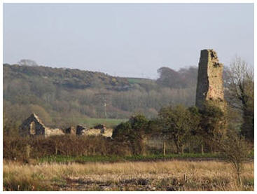
Berw Colliery
is the best preserved of a number of collieries that once formed the
Anglesey coalfield and is one of a number of 19th-century coal mines at
Malltraeth. It is unusual as it had a relatively short working life without the
change and development seen at many other collieries. It illustrates many of the
typical features of a small early nineteenth century Welsh coal mine. The shaft
was sunk in 1839 by Lord Boston and it worked till flooded out in the late 1868,
a 240hp steam engine was installed both to drain the mine and to raise the coal
to the surface. The remains include the engine
house, a possible boiler house, and a fine chimney stack. The site of the shaft
itself lies close to these structural remains. The ruinous domestic and working
ranges of a small farmstead are situated immediately adjacent to the colliery.
Known collieries
Berw Colliery,
Llanidan, Map Ref: SH 464725
Berw Uchaf Colliery, Llanidan (also called Tai
Hirion Colliery)
Dafarn Newydd Colliery, Llangristiolus
Esgeifiog Mine (coal), Anglesey
Gaerwen Syndicate Coal Trials, Llanidan
Glanymorfa Colliery, Anglesey
Glantraeth Colliery, Trefdraeth
Gwaithglo Colliery
Holland Arms Colliery, Llanfinhangel,
Esgeifiog. Map Ref: SH 469730
Llangeinwen Colliery, Llangeinwen
Malltraeth Bay Colliery, Trefdraeth
Maltraeth March Colliery, Trefdraeth, Map Ref:
SH 416690
Marquis Colliery, Llanidan, Map Ref: SH 424700
Menai Colliery, Trefdraeth
Morfa Mawr Colliery, Llangafo, Map Ref: SH
454716
Nant Colliery, Anglesey
Nantporth Colliery, Anglesey
Nineveh Colliery, Anglesey
Paradwys Mine (coal) Anglesey
Pencrug Colliery, Llangristiolus, Map Ref: SH
426708
Penrhyn Mawr Colliery, Anglesey
Pentre Berw Colliery,
Anglesey
Pont Marquis Colliery, Trefdraeth
Taecroesion Colliery, Anglesey
Tanyrallt Colliery, Llangristiolus
Trefdraeth Colliery, Trefdraeth
Tyddyn Mawr colliery is considered to be a
good surviving seventeenth century example.
Tyn Y Fflat Colliery, Trefdraeth, Map Ref: SH
418697
Most of the collieries
worked the seams via shafts. The seams are overlaid by very wet strata. Water
pumping problems was the usual reason for the failure of these pits.